![]()
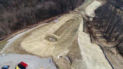
Keystone’s photogrammetrists use data from UAV flights to create 3D digital terrain models prior to developing site construction plans. This technology enables surveyors to gather far more ground data in one day of field exploration than ever before, and UAVs are able to collect data in areas that are considered unsafe for field crews to walk. This photo shows a steep slope above an old sediment trap pond in southwest PA. A developing slip above the trap made conditions too dangerous for the client to allow access on foot. Keystone mapped the entire slope using a UAV and created a remediation plan to reclaim the pond and create a stable slope at the site.


Keystone utilizes UAVs to provide efficient visual inspections and documentation of our client’s...
Keystone utilizes UAVs to provide efficient visual inspections and topographic mapping of as-built...

Keystone utilizes UAVs to provide efficient visual inspections and topographic mapping of pipeline...