linkedin facebook
Keystone utilizes UAVs to provide efficient visual inspections and topographic mapping of pipeline...
Read More
During the development of a proposed 60 mile natural gas pipeline across 3 counties affecting more than 300...
As part of the development of 25 miles of new 138 kV transmission line across 2 counties affecting more than...
Keystone integrates GIS and 3D Geospatial Data with all of the company’s services, especially our...
Since 1996, Keystone has been providing natural gas transmission clients with GIS mapping for field routing,...
Keystone produced 200 scale plan and profile alignment sheets for 100 miles of a 42” gas transmission line...
Keystone has a team of civil engineers, construction representatives, and environmental scientists who work...
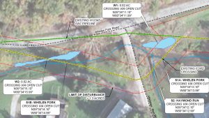
Keystone’s environmental group regularly prepares permit documents for the submission of stream and wetland...
Keystone’s client was proposing to install a 6 MG freshwater impoundment, gravel access road, and gravel...